


9.2 km | 11 km-effort
![Trail Walking Longny les Villages - [Itinéraire] La Brisardière - Photo](https://media.geolcdn.com/t/1900/400/19108d03-3d8a-43b4-b05b-172408edde68.jpeg&format=pjpeg&maxdim=2)

User


FREE GPS app for hiking
 SityTrail
IGN / Geographical institutes
SityTrail World
The world is yours!
Trail Walking of 3.5 km to be discovered at Normandy, Orne, Longny les Villages. This trail is proposed by ODDAD78.
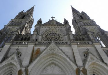
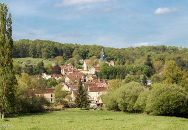
Ce circuit vous fera découvrir le patrimoine de Longny-au-Perche, notamment un de ses joyaux, la Chapelle Notre-Dame-de-Pitié. Point de vue exceptionnel sur le village.
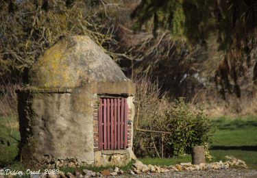
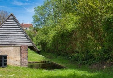
Mêlant randonnée et circuit du patrimoine, vous pourrez découvrir au fil des anciennes rues de belles maisons à colombages, l’ancienne école Saint-Martin (à gauche avant de tourner dans la rue du Pont Boivin), la Villa Jumeau, la Chapelle Notre-Dame de Pitié, le charmant hameau de la Brisardière. Retour ombragé le long de la rivière La Jambée, en passant devant le Foyer Rural, ancienne tannerie, le Vieux Logis, le Square Eugène Cordier, le Vieux Moulin, le château et l’église Saint-Martin.
Pas à Pas (Rando-Perche)
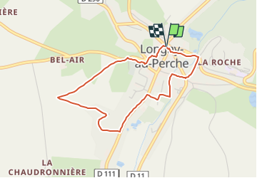
Départ : Longny-au-Perche, place de l'hôtel de ville Arrivée : Longny-au-Perche, place de l'hôtel de ville Balisage : PR
Communes : 1. Longny-au-Perche
Départ place de l’Hôtel de Ville devant l’Office de tourisme.
1. Prendre la rue Gaston Gibory . Tourner à droite rue du Pont Boivin. Laissez la Villa Jumeau sur votre droite et continuer tout droit. Traverser la rue du Docteur Boulay et monter les 33 marches qui vous mènent à la Chapelle Notre-Dame de Pitié.
2. A la sortie du cimetière, prendre le chemin gravillonné qui monte sur le plateau. Beau point de vue du village de Longny. Suivre le chemin de terre qui vous amène au lieu-dit la Brisardière sur la gauche. Traverser la D111 et revenir sur la gauche jusqu’à la rue de la Seigneurie (après l’Intermarché).
3. Prendre légèrement à droite pour rejoindre le cours de la rivière La Jambée. Prendre à droite au niveau du Pont Rouge, longer le Foyer rural et le Vieux Logis.
4. Traverser le carrefour de la Renaissance et prendre la rue de la Fontaine d’or puis à gauche la rue du Vieux Moulin qui vous ramène vers l’église Saint-Martin et la place de l’Hôtel de Ville.
![Trail Walking Longny les Villages - [Itinéraire] La Brisardière - Photo 1](https://media.geolcdn.com/t/2048/auto/9a2af061-7e63-4087-a8f3-4d18091a23ce.jpeg&format=jpg&maxdim=0 "Trail Walking Longny les Villages - [Itinéraire] La Brisardière - Photo 1")
![Trail Walking Longny les Villages - [Itinéraire] La Brisardière - Photo 2](https://media.geolcdn.com/t/2048/auto/19108d03-3d8a-43b4-b05b-172408edde68.jpeg&format=jpg&maxdim=0 "Trail Walking Longny les Villages - [Itinéraire] La Brisardière - Photo 2")
![Trail Walking Longny les Villages - [Itinéraire] La Brisardière - Photo 3](https://media.geolcdn.com/t/2048/auto/2d2b5e7c-7ff1-453a-bb41-79daac9b918a.jpeg&format=jpg&maxdim=0 "Trail Walking Longny les Villages - [Itinéraire] La Brisardière - Photo 3")
![Trail Walking Longny les Villages - [Itinéraire] La Brisardière - Photo 4](https://media.geolcdn.com/t/2048/auto/e66276a8-6d9a-4b89-9080-d8d9e1e9f92d.jpeg&format=jpg&maxdim=0 "Trail Walking Longny les Villages - [Itinéraire] La Brisardière - Photo 4")
![Trail Walking Bizou - [Itinéraire] Les sables du Perche - Photo](https://media.geolcdn.com/t/375/260/6b586e88-fad3-40df-be07-9b2a61186b9b.jpeg&format=jpg&maxdim=2)
Walking
On foot
Walking
Walking
Walking
Walking
Walking


Walking